FAQs
Major Anderson Shipwreck
-
After its wrecking in 1871, the Major Anderson's salvage rights were sold, and its rigging and deck machinery were removed. The site remained forgotten until its rediscovery in May 2013 by ultralight pilots. Today, the barkentine Major Anderson lies on the lakebed in 3 to 10 feet of water, about 4 miles north of Two Rivers, Wisconsin. Although her upper components were salvaged, her lower hull remains largely intact and well-preserved under an estimated ten feet of sand, making it an attraction for visitors to Point Beach State Forest, though it is lightly visited by kayakers, divers, and snorkelers.
-
The Major Anderson shipwreck is located in Lake Michigan at 44° 10.928' N, 87° 30.978' W.
Additional details about the shipwreck: Location: The remains of the 1861 barkentine rest on the lakebed in 3 to 10 feet of water, about 4 miles north of Two Rivers, Wisconsin, near Molash Creek.
-
The Wisconsin Shipwreck Coast National Marine Sanctuary is a protected area in Lake Michigan, designated in 2021 and co-managed by NOAA and the state of Wisconsin. It covers 962 square miles and contains 36 known historic shipwreck sites, with research suggesting up to 60 more may be undiscovered. Its purpose is to provide stewardship for the nation's maritime heritage, offering opportunities for research, resource protection, education, and promoting recreation and heritage tourism in partnership with local communities.
-
The Major Anderson was a barkentine, a relatively uncommon type of sailing vessel on the Great Lakes, characterized by having three or more masts with specific sail rigging (square-rigged fore and mainmasts, and fore-and-aft rigged mizzen mast). Constructed in 1861 by Ira Laffrinier, it was one of only two known barkentines in Wisconsin waters. This vessel type was crucial for the Midwest's economy, as it transported bulk cargo like coal, lumber, corn, and wheat across the Great Lakes, vital for infrastructure before extensive road and rail networks were developed.
-
The Major Anderson was lost on October 7, 1871, near the mouth of Molash Creek, four miles north of Two Rivers, Wisconsin. Captain John C. Sullivan became disoriented due to dense smoke from regional forest fires (including the Great Chicago Fire and Peshtigo Fire) and heavy gale conditions, causing him to run the vessel ashore. The ship's small boats were damaged, forcing the crew to swim to shore. Despite attempts by a tug to render assistance, the Major Anderson and its cargo of coal were declared a total loss, eventually breaking apart.
-
Named after Major Robert Anderson of Fort Sumter fame, the Major Anderson was launched on April 13, 1861, in Cleveland, Ohio. She measured 153.87 feet long, had a breadth of 33.20 feet, and a depth of 12.13 feet, costing $22,000 to build. The vessel proudly displayed an American flag and a painting of Fort Sumter on its stern. Throughout her career, the Major Anderson hauled various bulk cargoes on the upper Great Lakes, serving the region from the Civil War era through the height of the lumber boom.
-
Suzze Johnson is a local resident known for locating numerous historic shipwrecks, particularly at Rawley Point in Two Rivers, which is part of the Wisconsin Shipwreck Coast National Marine Sanctuary. She has discovered six of the 12 named wrecks at Rawley Point, including the Major Anderson, Tubal Cain, Lookout, LaSalle, Alaska, and Grace Patterson. Notably, she is the only person to have discovered this many shipwrecks on Lake Michigan using an ultra-light aircraft.
Municipal Court
-
-
No, they don't go away. These unpaid fines can prevent you; from getting a driver's license, your State refund check, ruin your credit, and even get you brought in before the Judge.
-
You may do the following:
- Pay the ticket before the court date as stated on the ticket -OR-
- Appear in court on the court date and enter your plea of "not guilty", "guilty", or "no contest" -OR-
- Write a letter to the court before the court date and enter a plea of "not guilty" at which time you will be sent a notice to appear for a pre-trial conference with the City's Prosecutor.
If the citation is marked "Mandatory", you must appear.
-
Failure to pay your fine by the due date will result in one or more of the following actions being taken: A commitment will be issued, your driver's license will be suspended, we will intercept you State Tax Refund, and/or refer your debt to a collection agency.
If you can not pay your fine by the due date and to avoid the above actions being taken, you must contact the Municipal Court Clerk or the Police Department's Administrative Lieutenant to get approval for an extension. This will generally be granted provided you have made a significant effort to pay the fine by the due date.
Installment Payment Plans will be offered to a traffic offender who is unable to pay a forfeiture because of poverty before the offender's driver's license is suspended. (Effective date of June 13, 2009)
-
If you do not take one of the above options, on the day you were to appear in court, you may be defaulted and found guilty as charged.
If you signed a personal recognizance bond, a notice will be sent that you were found guilty and your fine will be due by a particular date.
If you did NOT sign a personal recognizance bond, a warrant will be issued for your arrest for non-appearance.
Neshotah Beach Concession Stand and Restroom Renovation
-
No. This idea was considered. Feedback from the City Council and the community has shown that this option is not desired.
-
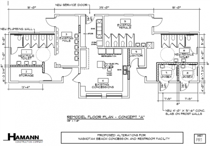
Yes, an interior renovation of the bathrooms, concession stand, and picnic shelter are being considered. See proposed floor plan changes to the building below.
-
The renovation would primarily include improvements to the restrooms. It will include all the following.
- Reconfiguration of restrooms to increase the number of toilets in both restrooms and reduce waiting times
- Creation of fully ADA-accessible restrooms, which do not currently exist in the building
- Addition of family-style restrooms and changing rooms
- Separate exterior-access restrooms to allow for year-round use by park visitors
- Replacement of all fixtures with modern, energy-efficient plumbing and appliances
- Three-season upgrades to the attached picnic shelter, including roll-up screens and radiant electric heaters
- Removal of non-load-bearing interior walls to create additional storage and counter space for the concession stand
- Completion of required health code updates to improve concession stand functionality
-
A full interior renovation is being considered because the Neshotah Beach building, originally constructed in 1955, is structurally sound and well positioned to continue serving the community and visitors for another 70 years if modernized. The renovation would significantly improve restroom capacity, particularly addressing long wait times in the women’s restrooms, and replace outdated open changing areas with more private, functional spaces. Interior showers are not planned but additional beach style exterior showers are. The project would create year-round restroom access for park users, an important amenity beyond the summer beach season. In addition, certain health code and concession upgrades are required regardless, and a comprehensive renovation allows those improvements to be done efficiently while also increasing space and functionality. The project would extend the usable season of the attached picnic shelter, creating new rental and revenue opportunities. Because the building’s interior walls are non-load bearing, the space can be reconfigured to better meet current and future needs without compromising the integrity and historic charm of the structure.
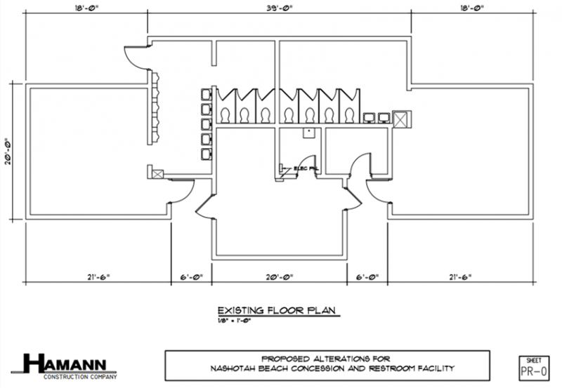
Current Beach House Floorplan
Proposed Beach House Floor plan
-
The current concession stand does not meet health code in several ways. These include the need for a three-compartment sink, exposed ceiling woodwork and walls, and sealing of the floors. Reconfiguration of plumbing, electrical, and counters would be needed to accomplish these improvements. The County Health Department has been flexible and collaborative in helping the city keep the stand running.
Minimum updates would also include making improvements to the space to keep it in general good repair, improve functionality for staff, and improve revenue generation potential. These include new storage racks, replacing a residential refrigerator with commercial, replacement of counters and cabinets, purchasing two commercial stand-up freezers, replacement of old point of sale technology, and installing improved lighting and electrical outlets.
Together, the health code improvements and general improvements are estimated to cost $43,000. Yes, we could only do these minimum updates.
-
No. The current concession stand functions more like a “snack shack” with hotdogs, frozen pizzas, pretzels, and other summer treats. If the space is renovated, the scope of the services will change some to accommodate other easily prepared foods. A renovated space would provide the opportunity for the city to lease the space to an outside vendor who may decide to serve different items. At this point in time, City staff are planning to continue operating the concession stand internally with a similar scope of service. There will be no indoor seating, no fryer, and no cooking range.
-
The total estimated project cost for full interior renovation is $510,636. This is an estimate put together by a local construction company and the Parks and Recreation Department. If the project proceeds, the city will be required to execute a competitive bidding process. There is no cost to do competitive bidding. The final amount could be less or more, but we feel the estimate is very close to reality.
-
No, definitely not. The city team has already begun submitting grant applications to support the cost of this project. We are not required to accept these grants if awarded. Funding this project effectively hinges on a grant from the State of Wisconsin for local infrastructure improvements. We have applied for a $255,318 grant from this state program. The Two Rivers Room Tax Commission has also committed a potential maximum amount of $125,000 over five years for the project. This places the current estimated city investment at $130,318. City staff will continue to pursue grants and fundraising to reduce this city investment.
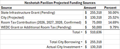
In this scenario, RTC support will be received over a three-to-five-year period. This means the city will need to borrow the full amount up front and be paid back by the Room Tax Commission. This is one of the ways the Central Park West project was funded. The $125,000 RTC contribution exceeds the estimated cost for the picnic shelter improvements at $105,000. Without RTC support, even with eliminating the picnic shelter improvements, the project would cost more to taxpayers.
-
There is potential for additional donations and sponsorships to reduce the tax-payer investment. A fundraising campaign will be started once the City Council has provided a firm commitment to pursuing the project. These efforts could take the form of donor recognition plaques and/or naming rights to specific areas of the facility. There is much to be determined in this area, and the total additional financial commitment will be greatly affected by how much interest there is from sponsors.
-
No. When a full rebuild was proposed, a year-round indoor rental space was suggested, like those found at Lincoln Park in Manitowoc. This idea is no longer included in the interior renovation proposal.
-
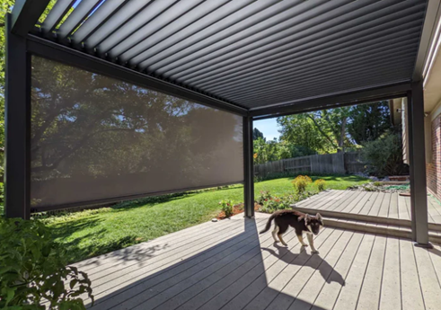
No, however, there will be improvements to make the shelter more comfortable in spring and fall. The proposed idea is to have retractable roll-up screens on the sides of the picnic shelter and to add radiant electric heaters to the ceiling. The idea of garage doors was suggested but roll-up screens are more cost effective and practical. Yes, there will be some added utility costs to have the heaters running during a rental event, but this will be offset by an increased number of rentals and rental rates. The renovation will also provide those renting the picnic shelter with access to the concession stand space as a warming kitchen (only when the stand is closed for the season). See example image below of the roll-up screens.
-
The Two Rivers Room Tax Commission (RTC) is a local advisory body that oversees how lodging tax revenues collected from hotels, motels, and short-term rentals are used to support tourism in the City of Two Rivers. Wisconsin law restricts these funds to tourism promotion and tourism-related facilities and events, meaning they cannot be used for general city operations, beyond an initial 30% contribution to the City General Fund. The Commission is made up of primarily tourism industry representatives along with City representation.
See Wis. Stats. 66.0615 and Chapter 66.0615, at Wisconsin.Gov
Yes, RTC has committed $25,000 per year for three years to the project. The RTC has also committed to supporting two additional years at $25,000 each if the city is unsuccessful in securing a pending $50,000 grant to the Wisconsin Economic Development Corporation. This places the potential total RTC contribution at $125,000 over five years.
-
Yes, but this is very unlikely. The amount of room tax collected each year has been steadily increasing. (2025 did see a slight decrease because of a general slowdown in the overall economy.) There are many reasons to be optimistic that room tax will stay stable. One of those being the creation of additional lodging opportunities coming online in 2026. The Room Tax Commission has a proven track record for making this type of investment with a similar investment level for the Central Park West renovation.
-
Yes. RTC is legally required to support projects that increase overnight stays in the community. The concession stand and restroom are an important amenity to visitors to the community. However, to fully meet the statutory requirements for spending RTC funds, the RTC has asked the city to include improvements to the attached picnic shelter. Improving the picnic shelter into a more comfortable three-season venue creates the opportunity for increased overnight stays by attracting more and larger gatherings.
The $125,000 RTC contribution exceeds the estimated cost for the picnic shelter improvements at $105,000. Without RTC support, even with eliminating the picnic shelter improvements, the project would cost more to taxpayers.
-
No. A revenue bond will not be used to fund the renovation. A revenue bond was suggested as a means for funding a brand-new building. A revenue bond is a loan that would be paid off using new revenue generated by the project.
-
Yes. The current concession stand generates around $10,000 in net revenue per year after covering all seasonal staffing, supplies, and full-time staff time for coordination. This revenue is used to help cover the cost of July 4th Fireworks, Thursday Concerts in the Park, and Bands on the Beach. These special events are fully funded through the concession stand, sponsorships, and donations.
Open Gym FAQ
-
Click here to view the Open Gym Calendar, which is updated in real time. The calendar shows when the gym is rented; any other time during normal hours is available for public use.
-
The gymnasium is open during normal Community House business hours:
- Monday–Friday: 6:00 AM – 8:00 PM
- Saturday–Sunday: 7:00 AM – 6:00 PM
-
Open Gym is open to the public (for kids in grades 6 and up) whenever the gym is not reserved for events or rentals.
Opportunity Grant Explore Page
-
You may apply for more than one grant in a calendar year. Please note that an event will not be eligible for funding if the event has received funding for two consecutive years.
-
You may apply for funding for events that take place outside of the city limits of Two Rivers. However, funding in this case must have a direct correlation that leads to overnight stays in the City of Two Rivers
-
You may apply for funding to support an event or program that takes place in the next calendar year. If your grant application is approved, you will receive the requested funds in the application year.
-
Opportunity Grants are available to non-profit and for-profit organizations.
-
We highly encourage any organization looking to pursue an Opportunity Grant to contact the Tourism Department if you have questions. We are here to support your efforts and will assist you with the grant process.
-
Because Opportunity Grants are funded through room tax revenue, the Explore Board of Directors is taking every precaution to ensure that organizations and events are in good standing with the IRS and have demonstrated good fiduciary responsibility.
Parks and Recreation
-
Animals are prohibited at Neshotah Beach from May 1 through September 30 of each year, except that leashed animals are permitted between the hours of 6:00 AM and 10:00 AM.
For purposes of this ordinance, Neshotah Beach is defined as the area at Neshotah Park lying between the lakeward edge of the concrete Beachwalk beach parking lots and the waters of Lake Michigan, inclusive of the concrete beachwalk. Said area shall extend from the north pavement edge of the northernmost beach parking lot, as extended to Lake Michigan, to the south pavement edge of the southernmost parking lot, as similarly extended.
Continue reading ordinance
In Summary:
- No leash required on public beach along Mariners Trail.
- Leash required on beach from North pier to southernmost Neshotah Beach parking lot.
- No dogs allowed on Neshotah Beach, regardless of leash, from May 1st to September 30th, 10:00 am – 11:00 pm. However, leashed dogs are permitted from 6:00 am – 10:00 am on Neshotah Beach.
-
No.
-
Visit the website here or visit TRrecConnect.com
-
Two Rivers continues to have needs for benches at the new park at Neshotah. If you are interested in donating to one of those locations contact the Recreation Department at (920-793-5592) or click here.
-
Daily 6:00 AM - 11:00 PM
-
Mon - Fri 6am - 8pm
Sat & Sun 7am - 6pm
-
We do not have discount attraction tickets available this year.
-
In-person only begins on the second Monday of December & online the following day.
-
We are excited to introduce our new J.E. Hamilton Community House Gym Calendar!
By clicking on the link below, it will bring you to the calendar for the gym updated in real time so you won't have to wonder if the gym will be open to the public!
Please note that this calendar shows you when the gym is being RENTED, so any other time during normal Community House Business Hours it would be available for use. Normal hours are Monday-Friday 6am-8pm and Saturday-Sunday 7am-6pm.
Click here to see the calendar.
Open Gym Rules
- Kids Must Stay in the Gym
- All kids must remain in the gym while they are in the building. Wandering around other areas is not allowed.
- No Food Allowed in the Gym
- To maintain cleanliness and ensure safety, no food is permitted inside the gym at any time.
- No Running Through the Lobby or Stairways
- For the safety of all participants and visitors, running is prohibited in the lobby and stairway areas.
- No Cursing
- Respectful language is expected at all times. Cursing or use of offensive language is strictly forbidden.
- No Loud or Disruptive Behavior
- Please be considerate of others. Loud or disruptive behavior will not be tolerated.
- Stay Off the Stage
- The stage area is off-limits during open gym hours. Please do not climb or play on the stage.
- Open to Kids in Grades 6 and Up
- The open gym is available to children in grades 6 and up.
Failure to follow open gym rules could result in disciplinary action up to suspension or a no trespass order without verbal or written warning based on severity.
- Kids Must Stay in the Gym
Police Department
-
While an officer may become aware of a vehicle parked longer than the 48 hours allowed, citizens know their own neighborhood better. Call us and give us the location and a description of the vehicle, including license number (if available). A report will be generated and an officer will be assigned to initiate an investigation. An officer will then be assigned after 48 hours to determine if the vehicle had been moved. If it hasn't, a parking ticket will be issued. The vehicle will stay on our list for another 48 hours and ticketed again. A vehicle that remains beyond this can be deemed abandoned. A process then begins to identify and locate the owner. If the owner cannot be located or if there is continued non-compliance, the Police Department can tow the vehicle. The abandonment process continues after this. To make such a report, you can call our dispatch center at 920-686-7200 or stop at the Police Department to make a report.
-
Find information on Wisconsin's top consumer complaints, get the facts on deceptive business practices and scams. Consumer Protection Hotline: 1-800-422-7128 Or; Department of Agriculture, Trade and Consumer Protection website: http://datcp.state.wi.us/core/consumerinfo/
-
Yes there is. Curfew hours for all children 17 years old and younger are:
11:00 PM until 5:00 AM Sunday through Thursday and;
12:00 AM until 5:00 AM on any Saturday or Sunday morning.
Offenses:
A minor (a child 17 years of age or younger) commits an offense if the minor remains in any public place or on the premises of any establishment within the City during curfew hours.
A parent or guardian of a minor commits an offense if the parent or guardian knowingly permits, or by insufficient control, allows the minor to remain in any public place or on the premises of any establishment within the City during curfew hours.
The owner, operator, or any employee of an establishment commits an offense if the owner, operator, or any employee knowingly allows a minor to remain upon the premises of the establishment during curfew hours.
There are exceptions:
a. If the minor is accompanied by the minor's parent or guardian;
b. Is in a motor vehicle in interstate travel;
c. Is engaged in any employment activity or going to or returning home from an employment activity, without any detour or stop;
d. Is involved in an emergency;
e. Is on the sidewalk abutting the minor's residence or abutting the residence of a next door neighbor if the neighbor did not complain to the Police Department about the minor's presence;
f. Attending an official school, religious, or other recreational activity supervised by adults and sponsored by the City of Two Rivers, a civic organization, a religious organization, or other similar entity that takes responsibility for the minor or going to or returning home from, without detour or stop, one of the above mentioned recreational activities.
g. Is exercising first amendment rights protected by the United States Constitution such as free exercise of religion, freedom of speech and the right of assembly; or
h. Is married or had been married or had disabilities of minority removed in accordance with Wisconsin Law.
Pamphlets which explain more detail, including penalties, are available at the Two Rivers Police Department.
-
Only if the officer specified that requirement on the warning notice. Otherwise your signature is valid proof that the defect was repaired or corrected. Please follow the instructions on the warning notice.
-
You can report incidents such as these to the Two Rivers Police Department in a number of ways.
1. You can call our dispatch center at 920-686-7200
Or
2. You can stop down at the police department to report the matter in person.
Or
3. You can fill-out and submit our "Blighted Properties and Junk Vehicles Form" on this web-site. Go to our "Forms & Documents" or the link in our Services section.
-
Ordinance 9-2-5 prohibits loud and unnecessary noise and sets limits for day and night. In a residential zone, noise during the daytime (7AM-10PM) may not exceed 60 decibels. At night (10PM-7AM), noise may not exceed 50 decibels. Those readings are taken from the lot line of the nearest complainant. At night, no stereo or amplification device may be played in such a way that it is plainly audible at the property line of the building, structure, or vehicle in which it's located. There are some exceptions for construction noise. Fines for violations can run over $100. Contact the police department with further questions in regard to this ordinance or read the ordinance here.
-
For the purpose of this question, a "trailer" is defined to mean any unpowered vehicle or device designed for carrying property or passengers wholly on its own structure and for being drawn by a motor vehicle on a road, street or highway. The most common trailer(s) dealt with are boat, camper, utility and construction trailers.
This ordinance directs that no person shall park, store or maintain any trailer on any city street in any residential area in the City of Two Rivers between the hours of 2:00 AM and 6:00 AM, unless the trailer is attached to a motor vehicle that is in operating, and licensed, condition.
The exception to this ordinance is that it shall not apply to trailers being used by contractors, while rendering services to a property, parked on the street if the trailer is lawfully parked on the street next to the construction location and the trailer does not present a traffic hazard.
Authority - Two Rivers Municipal Ordinance 8-2-13It is also contrary to City ordinance to park any vehicle, boat or "trailer" on any street or at any parking lot continuously for more than 48 hours.
Authority - Two Rivers Municipal Ordinance 8-2-3 -
The terrace is the land between the normal location of the street curbing and sidewalk. Where there is no sidewalk, the area four foot, six inches from the curb line shall be deemed to be the terrace for the purpose of this section.
Municipal Ordinance 8-2-11, Parking On Terrace, states that (a) No person shall park any vehicle, boat or trailer on a terrace unless they have received a permit to do so from the Chief of Police. (b) The Chief of Police may issue a permit to park on the terrace, between December 1 and March 15, when the person receiving permission is the owner or tenant of the adjoining property, and (1) When that person has exhausted all available parking facilities on his property, and (2) When parking on the terrace will not inhibit snow removal or interfere with public safety, and/or public welfare. (c) If permission to park on the terrace is received, all parking ordinances which are in effect for this area must be observed, except Section 8-2-4 of the City Code entitled, "All Night Parking Prohibited." The Chief of Police may impose additional conditions and restrictions as he deems necessary, and shall include same in said permit. (d) The permit shall be effective from December 1 through March 15 of each year. The permit my be rescinded by the Chief of Police if the permit holder fails to conform to all the conditions of the permit.
-
Winter parking restrictions are in effect December 1st to March 15th. During this period parking is prohibited on ANY PUBLIC STREET or in ANY MUNICIPAL PARKING LOT between 1:00 AM and 6:00 AM. In business areas, parking is limited to one hour between 1:30 AM and 6:00 AM. Parking is allowed on Christmas Day (December 25) and New Year's Day (January 1st) unless a snow emergency is declared. Frequently the City of Two Rivers will suspend the parking ban when above average temperatures, pleasant weather, and there is no need for street cleaning in the forecast. When the ban is suspended, the City will post that information on the East Park St digital sign and the City of Two Rivers Facebook, and we will share that information on our Facebook page.
Program FAQ
-
Yes, most programs are open to both residents and non-residents. Some programs may have different fees based on residency.
-
Yes! Two Rivers Parks & Recreation strives to make programs accessible to all community members. Financial assistance may be available for eligible participants. Please call us at (920) 793-5592 , stop by the Community House, or Apply Online.
-
Our programs are always evolving! You can stay up to date by:
- Visiting our online registration site: TRrecconnect.com
- Calling us at (920) 793-5592
- Stopping by the Community House Fireplace Lobby, 1520 17th Street, Two Rivers
- Following us on Facebook for announcements
- Reading our newsletter for upcoming activities
-
You can register online at TRrecconnect.com, by phone at 920-793-5592, or in person at the Community House in the Fireplace Lobby. Payment will be made at the time of registration.
-
We’ll notify participants by email, and updates will also be posted on our Facebook page.
-
If a program is full, you can join a waitlist online or by calling our office. We’ll contact you if a spot becomes available.
Search Tips and Tricks
-
Yes. The website indexes web pages as well as PDFs, Microsoft Office documents, and text documents.
-
No. By default, the search results will show matches for any word within the phrase. In this example, you would receive results for all web pages and documents that contained either the word alarm or the word permit or both.
In order to search on an exact phrase, enclose your search phrase in quotations. The search results for "alarm permit" will show matches for that exact phrase.
-
Yes. You can exclude words by using the minus sign (-). In order to find the results of all pages that have alarm in the result but not permit, you would search for alarm -permit.
Spirit of the Rivers FAQ
-
Each figure is approximately ten feet tall, and the canoe is about 20 feet long.
-
The completed sculpture weighs over three tons.
-
It was developed from a small maquette to full-scale clay figures, then cast in bronze at a fine art foundry.
-
Parking, picnic areas, and restrooms are available at the Woodland Drive wayside nearby.
-
It represents family, travel, survival, and the deep connection between Native peoples and the waterways.
-
The sculpture includes a man carrying a birch bark canoe, a woman carrying belongings, and an elder guiding the group.
-
A maquette is a small working model used to plan and refine the final sculpture.
-
Spirit of the Rivers is a monumental bronze sculpture group celebrating the culture and history of the earliest inhabitants of the Lake Michigan shoreline.
-
It honors the everyday life and legacy of Native peoples who lived along the Great Lakes for countless generations.
-
The sculpture is cast in bronze.
-
It can be viewed along Mariners Trail with open sightlines from Memorial Drive.
-
The sculpture is located along the Lake Michigan shore on Mariners Trail at the boundary between Two Rivers and Manitowoc.
-
The bronze casting was completed at a fine art foundry in Oregon.
-
The monument recognizes the Menominee, Ojibwa, Ottawa, Potawatomi, and other Wisconsin tribes.
-
The idea was conceived by local resident Joseph Metzen and sculptor R.T. “Skip” Wallen.
-
The project was supported by private donations.
-
The sculpture was created by Skip Wallen, an internationally recognized artist and Manitowoc native.
-
It serves as a lasting tribute to the region’s first people and a point of pride for residents and visitors alike.
-
The birch bark canoe symbolizes transportation, exploration, and cultural development in the Great Lakes region.
The Continental Shipwreck
-
Yes, it is a very comfortable paddle out to the Continental. It is clearly marked from shore during the months of July through September. The buoys are visible from shore.
-
The Continental's working life was primarily characterized by a regular run between Cleveland, Ohio, and Marquette, Michigan, often towing consorts to increase its cargo capacity. While largely uneventful, it experienced some mishaps, such as its towlines snapping three times while attempting to free the schooner Sumatra in 1883. A more serious incident occurred in April 1890 when a fire broke out onboard, leading to a collision with its tow, the Magnetic, which subsequently sank. The Continental was able to rescue all of the Magnetic's crew.
-
The Continental shipwreck is a protected site, added to the National Register of Historic Places in 2009. It is also located within the Wisconsin Shipwreck Coast National Marine Sanctuary, designated in 2021. State and federal laws protect this shipwreck, meaning divers are not permitted to remove artifacts or structural components from the site. Removing, defacing, displacing, or destroying artifacts or sites is considered a crime.
-
Yes, the Continental is visible from shore.
-
After the stranding, attempts were made to dislodge the ship from the sandy bottom once the less violent weather set in. The Arctic from Manitowoc was the first to attempt salvaging, followed by the Reid Wrecking Company out of Port Huron, Michigan. However, these efforts proved unsuccessful, and as winter progressed, ice filled the hull, causing the Continental to break up. It was eventually declared a total loss with the surrender of its documents on December 8, 1905.
-
The Continental was a transitional class of Great Lakes bulk carrier that began to employ innovative hull strengthening technologies to accommodate greater gross tonnage and longer hulls. Its shipwreck is highly significant because little historical documentation exists on wooden bulk carrier construction and operation. Much of our understanding of this vessel type, which continues to play an important role in our economy and culture, comes from archaeological data recovered from wreck sites like the Continental. It offers a rare glimpse into the developmental years of this unique style of Great Lakes vessel.
-
The best place to park to visit the Continental shipwreck on the beach in Two Rivers is within Point Beach State Forest, accessible via County Road O, and then walk north of the Rawley Point Lighthouse. From this location, you can access miles of beach and walk north to find the shipwreck remains.
-
The wreckage of the Continental rests approximately 1.5 miles north of Rawley Point Lighthouse near Two Rivers, Wisconsin, in about 15 feet of water. Due to its position, the water level can fluctuate, ranging from 0 to 15 feet. Shifting fine sands periodically uncover and obscure different sections of the remains. While the hull has been broken apart by waves and ice, a large part of the machinery, including the double-expansion steam engine, remains intact.
-
The Continental shipwreck is located in Lake Michigan off the coast of Two Rivers, Wisconsin, at approximately 44°13′50″N, 87°30′31″W.
More specifically, the wreck of the 1882 bulk carrier lies in about 15 feet of water, 1.5 miles north of Rawley Point Lighthouse.
-
The Wisconsin Shipwreck Coast National Marine Sanctuary, co-managed by NOAA and the state of Wisconsin, was designated in 2021 to provide stewardship for the nation's maritime heritage in Lake Michigan. It expands on the state's 30-year management of historic sites, offering new opportunities for research, resource protection, and education. The sanctuary encompasses 962 square miles and includes 36 known shipwreck sites, 27 of which are on the National Register of Historic Places, with research suggesting another 60 may still be undiscovered. These sites represent vessels that were central to building the nation between the 1830s and 1930s, and the sanctuary promotes recreation and heritage tourism, safeguarding America's premier marine places.
-
On December 12, 1904, while traveling empty from St. Ignace, Michigan, to Manitowoc, Wisconsin, for winter repairs, the Continental encountered a blinding snowstorm. It missed its course change around Twin Rivers Point and steered west, striking a sandbar off Rawley Point Lighthouse. Because it was traveling light, its wooden hull rode high in the water, pushing it high onto the sandbar due to its speed. Fortunately, all twenty crew members were able to make their way safely to shore with the assistance of local fishing boats, with no serious injuries or loss of life.
-
The Continental was a wooden bulk carrier built by renowned shipwright George Presley in Cleveland, Ohio, in 1882. It was specifically ordered and owned by the Republic Iron Company for the iron trade, playing a crucial role in the industrialization of America by transporting bulk goods.
The LaSalle Shipwreck
-
Yes, it is a very comfortable paddle out to the LaSalle. It is marked during the months of July through September. The buoys are visible from shore.
-
Yes, the LaSalle is visible from shore.
-
On October 22, 1875, during its second season, the LaSalle departed Chicago with 22,000 bushels of wheat bound for Buffalo. On the night of October 25, while sailing into a gale near Two Rivers Point (now Rawley Point), it lost its rudder. Before Captain Parker could anchor the vessel, it struck bottom and drifted ashore, becoming embedded in hazardous quicksands. The ship filled with water, forcing the crew to spend the night in the rigging before being rescued by local fishermen the next morning. Despite efforts by tugboats Leviathan and J.J. Hagerman, the LaSalle could not be freed, was deemed badly damaged, and was declared a total loss. It was subsequently stripped of its anchors, spars, and some rigging, and then abandoned.
-
The best place to park for access to the LaSalle shipwreck on the beach in Two Rivers is Point Beach State Forest or the Neshotah Park & Beach, as both offer parking and convenient access to Lake Michigan's shore where the shipwreck is located. You can park in the designated areas within Point Beach State Forest, or at Neshotah Park, and then walk or bike to the beach to view the shipwreck.
Parking and Access
Point Beach State Forest: This is a state forest near Two Rivers with parking available. From the forest, you can access the Rawley Point Trail which leads to the beach, providing a great way to walk to the shipwreck.
Neshotah Park & Beach: This park is located in Two Rivers and also offers parking. From the park, you can easily access the beach and walk to the shipwreck location.
-
Today, the LaSalle shipwreck lies in twelve feet of water, offering easy access for kayakers, boaters, snorkelers, and beginning divers. Much of the vessel's original rigging, which was surprisingly not salvaged, was found balled up inside the hull, including wire rigging that supported the masts, deadeyes, and circular hearts. The distinctive iron deck knees, a key feature for its identification by archaeologists, are visible along the hull sides. The wreck's high level of hull integrity makes it a valuable site for historical and archaeological exploration.